Wednesday, April 22, 2015
Sandstone Arches
Sandstone Archesare wondrous and awe-inspiring constructs found in desert regions throughout the world. Yet the process behind the creation of these arches is even more impressive given its complexity. The arches themselves are formed through an erosion process in which the sand stone is weathered by either water or wind carrying small particles of dust or rock. Over thousands of years these processes wear away at the rock gradually creating gaps which eventually form the arch. A great example of such a stand stone arch would be the Delicate Arch in Arches National Park.

Wednesday, April 8, 2015
Community Gardens
Community gardens,are in essence a joint effort by a community to grow edible plants or foodstuffs for use by community members. In short the purpose of these gardens can range from providing the aforementioned food to community or poor folks or to allow for the growth of crops that can be sold. In short community gardens are a wonderful idea upon paper but there are some issues with the concept. Most of these issues stem from the poor quality of the soils or even the presence of toxins within the soil of the gardens.
Friday, March 20, 2015
Lab 5
For this lab we had to make an elevation line and graph, so what I did was take a measure of distance and elevation in my hometown of Roswell.

Then I took five points of elevation and put them into Excel
Then finally I added the graph by taking a screen shot of the finished product.
.jpg)
Then I took five points of elevation and put them into Excel
| Distancee(MI) | Elevation(FT) |
| 2 | 1177 |
| 4 | 1089 |
| 6 | 1144 |
| 8 | 1057 |
| 10 | 1033 |
| 12 | 1011 |
Then finally I added the graph by taking a screen shot of the finished product.
Rock Collection Lab
For this lab we had to go out and find about eight different types of minerals/rocks. So my friend and I went rock hunting around campus and what we found is displayed below.

Tuesday, March 10, 2015
Hydorthermal Vents
Hydrothermal Vents
Hydrothermal vents are openings within the planet’s surface
typically within trenches. Through these fissures rise hot gas and other
superheated fluids. Surprisingly within these fissures lie a large number of
varied lifeforms. The most prominent of
these life forms would be the tubeworm which lines the edges of the vents and
draws sustenance from internally dwelling bacteria. Finally, there is the Pompeii
worm which is a worm capable of surviving the extreme temperatures of the
trenches.
Hydrothermal Vent

Tube Worm

Pompeii Worm

Wednesday, February 11, 2015
Mica(silicate)

Mica is a member of the group of minerals known as the sheet silicates. Believe it or not there are actually a few different types of Mica but the two primary types are split under the tricotahedral and diocathedral types. In essence this means that it determines how they are structured. As stated previously Mica comes in some variations but typically vary by region. Arguably though, the most prevalent feature of mica is it's highly defined cleavage.
Learn more about Mica
Malachite:

Malachite is a gemstone known for its green color,a trait for which it is rather popular and multiple bands that cover its surface. As a gemstone Malachite is often used as a bead stone or used in necklaces as well. In addition Malachite is also known for its relative softness which makes it ideal for use in carvings well. Finally it should be noted that Malachite is often found within copper deposits which have made relatively cheap to purchase and use.
Malachite
Mica is a member of the group of minerals known as the sheet silicates. Believe it or not there are actually a few different types of Mica but the two primary types are split under the tricotahedral and diocathedral types. In essence this means that it determines how they are structured. As stated previously Mica comes in some variations but typically vary by region. Arguably though, the most prevalent feature of mica is it's highly defined cleavage.
Learn more about Mica
Malachite:
Malachite is a gemstone known for its green color,a trait for which it is rather popular and multiple bands that cover its surface. As a gemstone Malachite is often used as a bead stone or used in necklaces as well. In addition Malachite is also known for its relative softness which makes it ideal for use in carvings well. Finally it should be noted that Malachite is often found within copper deposits which have made relatively cheap to purchase and use.
Malachite
Chloropleth map

A chloropleth map is a map based around a central theme or factor which is meant show a statistic within a central boundary such as a state or province(even a country,) This particular map shows the average median income of households around the country. Furthermore notice how this map varies heavily by state and region to region.
Isarithmic map:

An isarithmic map shows a continually ongoing or constantly changing detail such as precipitation, temperatures, or population density. The ultimate purpose of this map is to give the sum total of precipitation rather than just a comparison. For example this map is shows the level of rainfall throughout the year in Washington State.
Proportion symbol map:

A proportion symbol map is meant to show a particular set of data in the vicinity of a general location or specific area. The data displayed on this map can be anything from showing the industrial production of a region to the population of an area. In this case this map shows the population of the capital of each state.
Dot Density map:

The purpose of the dot density map is to state the pervasiveness of a factor within an area. For example this map indicates the population of the United States by area, with each dot representing a hundred thousand people.
A chloropleth map is a map based around a central theme or factor which is meant show a statistic within a central boundary such as a state or province(even a country,) This particular map shows the average median income of households around the country. Furthermore notice how this map varies heavily by state and region to region.
Isarithmic map:
An isarithmic map shows a continually ongoing or constantly changing detail such as precipitation, temperatures, or population density. The ultimate purpose of this map is to give the sum total of precipitation rather than just a comparison. For example this map is shows the level of rainfall throughout the year in Washington State.
Proportion symbol map:
A proportion symbol map is meant to show a particular set of data in the vicinity of a general location or specific area. The data displayed on this map can be anything from showing the industrial production of a region to the population of an area. In this case this map shows the population of the capital of each state.
Dot Density map:
The purpose of the dot density map is to state the pervasiveness of a factor within an area. For example this map indicates the population of the United States by area, with each dot representing a hundred thousand people.
Wednesday, January 28, 2015
Stone Mountain Elevation Map

Table
1. Red Line:1000 FT
2. Yellow Line:1100 FT
3. Green Line:1200 FT
4. Blue Line:1300 FT
5. Orange Line:1400 FT
6. Dark Green Line:1500 FT
7. Lime Line: 1600 FT
Thursday, April 10, 2014
Dendrochronology Lab
For this lab the objective was to count the rings of two freshly cut trees and match up several important events to the rings.
To do this I had to take the pictures of the two trees and put them into paint to measure the approximate thickness of each ring. When this was completed the Georgia Pine was about 52 years old and the California Elm was about 29 years old.
The next part of the lab was to determine the historical precipitation levels for both Macon and Palm Springs. In order to do this I used a combination of data from the weather centers in Macon and Palm Springs as well as some data from a friend(Thank you Abby you rock!). Next I had to find the averages for the growing season and so I chose the summer months and averaged the temperatures to get the average temperature for each year.
To do this I had to take the pictures of the two trees and put them into paint to measure the approximate thickness of each ring. When this was completed the Georgia Pine was about 52 years old and the California Elm was about 29 years old.
The next part of the lab was to determine the historical precipitation levels for both Macon and Palm Springs. In order to do this I used a combination of data from the weather centers in Macon and Palm Springs as well as some data from a friend(Thank you Abby you rock!). Next I had to find the averages for the growing season and so I chose the summer months and averaged the temperatures to get the average temperature for each year.
Monday, March 17, 2014
Geology Lab
Igneous
Igneous Rocks are created when magma or lava hardens.
Granite:
Granite is one of the most notable and widely used igneous rocks due to its widespread use in buildings and monuments. One great example of a notable igneous rock is that of Stone Mountain which is the largest piece of exposed granite in the world.
Metamorphic Rocks
Metamorphic Rocks are created when heat, pressure, and chemical processes combine to act upon rocks underneath the Earth's surface.
The most notable metamorphic rock would be marble because of its widespread use in building statues and other monuments. It is formed when limestone is subjected to heat and pressure and it can even be crushd into a very fine powder.
Sedimentary Rocks
Sedimentary Rocks are formed via the gradual accumulation of sediments over many years.
A notable example of a sedimentary rock would be Coal which is used as fuel source by various nations. Coal is formed via fossilized ferns and plant matter which are slowly compacted before forming the rock.
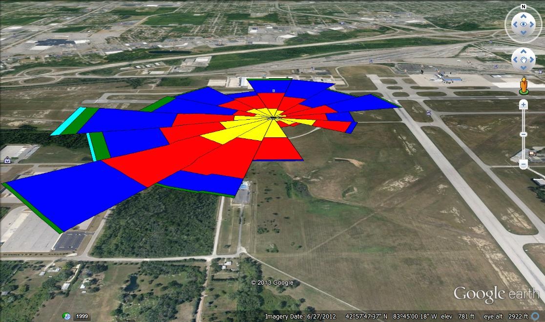
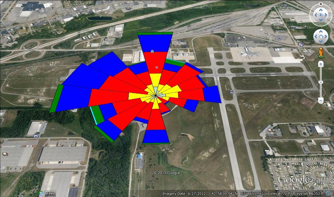
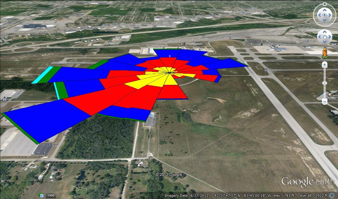
For the Windrose plots I used data from the Flint Airport station dating from 2001. I created these plots through the use of Lakes software and from there I exported them to Google Earth and took snapshots of them.
February
April
June
November
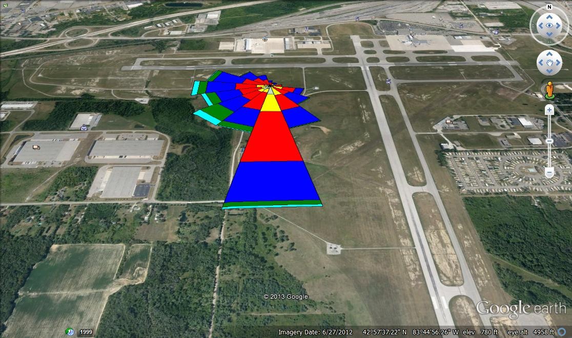
- I am sorry for the long wait Dr. rood but I had a great deal of trouble getting these graphs posted to blogspot and eventually I just decided to post it here.
Solar Trajectory Lab
For the solar trajectory lab, I actually had lot of trouble without and I had to borrow data from a friend of mine. For the graph I input the data and then plotted it.

From the data I plotted the points on the graph as you can see below.

* I would also wish to thank Jessica and Abby for helping by letting me use their data and graph.
Tuesday, March 11, 2014
Progress of Sunflower Growth( I.E Sunny's progress) [Reupload]
First Week Feb 24
The plant has not yet sprouted despite my watering of it and exposure to sunlight. I will cut back on the watering and start exposing it to more sunlight.
Second Week
The plant to my amazement has sprouted in spite of a lack of water. It is amazingly hardy for such a seemingly delicate organism. I will continue to observe the plant's progress.
Update: As of today I have decided to call the plant Sunny. Sunny continues to amaze me with his rapid growth despite the limited amount of sunlight on my windowsill. As for his height I would estimate him to be around two inches.
First Week Feb 24
The plant has not yet sprouted despite my watering of it and exposure to sunlight. I will cut back on the watering and start exposing it to more sunlight.
Second Week
The plant to my amazement has sprouted in spite of a lack of water. It is amazingly hardy for such a seemingly delicate organism. I will continue to observe the plant's progress.
Update: As of today I have decided to call the plant Sunny. Sunny continues to amaze me with his rapid growth despite the limited amount of sunlight on my windowsill. As for his height I would estimate him to be around two inches.
Monday, January 20, 2014
New computer/ new problems
Still getting the hang of this...
The objective of this lab was to determine the amount of rain that fell during a two inch rain storm in the WSC parking lot. Below are pictures of my attempts at creating a satellite photo of the parking lot.Edit: It is important to be able to measure the total volume of water because it allows us to design drainage systems to combat flooding. Through this the school can avert potential damage and financial loss.

Wednesday, January 15, 2014
Rachel Carson
Rachel Carson was a famous marine biologist best known for her controversial book Silent Spring. This book outlined how the use of the supposedly innocuous pesticide DDT was actually responsible for heavily damaging to the environments it was used in. Through the evidence presented in Silent Spring Carson was able to prove that DDT was a major factor in multiple cases of birth defects across the country as well as establishing a link between the pesticide and cancer.These revelations shattered the myth of DDT being a harmless chemical and led to the banning of its use by the American governmemt. Carson and her book played a key role in the early environmentalist movement as well. Until her death in 1964 Carson would use her book to help increase awareness of the damage being done to the environment by chemicals and large corporations which ultimately lead to the creation of the EPA. In addition to her wor on as marine biologist and conservationist Carson was a major figure in the formation of the early environmentalist movement and led to the rise of the modern feminist movement.
Wednesday, January 8, 2014
Subscribe to:
Posts (Atom)